
Anyone who has been following my journey so far will know it has not been easy! The dream when it was launched in April 2017 was for it to become a permanent waymarked route but that has not come to fruition.
It has been a challenge but a good one, quite the adventure – and I have loved finding new ways to walk with some incredible views that I've encountered for the first time.
Founded with the support of City Parks, the route through the South Downs National Park is promoted by the Brighton & Hove Way Association and it was the chairman who encouraged me to follow the walk. I planned it in six sections, using the map and what I thought would be the best ways to access the bus.
The third section from Stanmer Park to Westdene was always going to be tough because of the challenge of where to cross the A27. When it came to it, I ended up going slightly off route and found mysielf in a position where it was really best to plough on to Portslade.
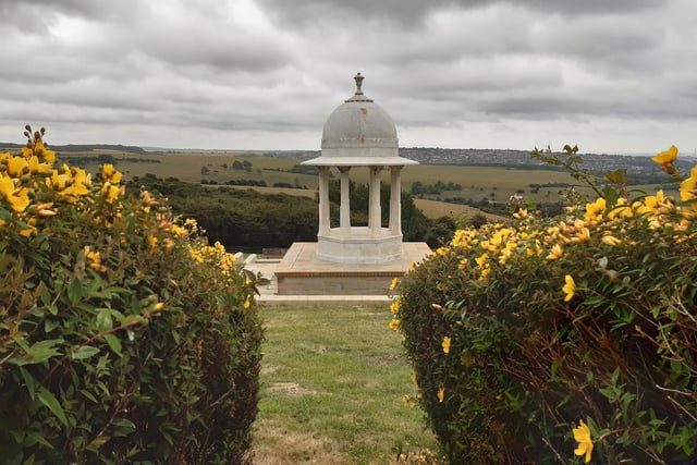
So this is now section three and four combined into one big 10-mile hike that is brilliant. I met so many people along the way, including a group of girls who kindly helped me with my directions. I also got to visit the Chattri Memorial and that was a real special moment.
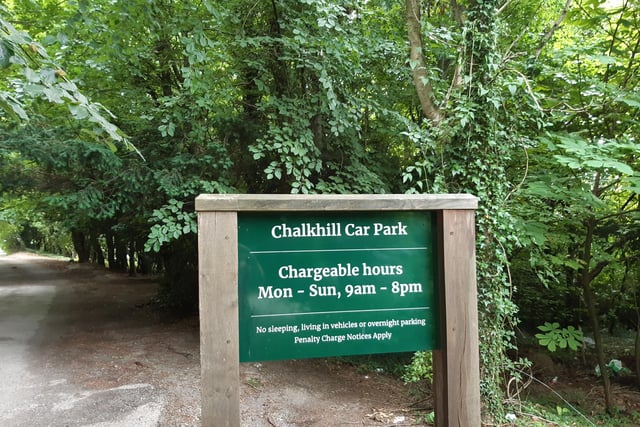
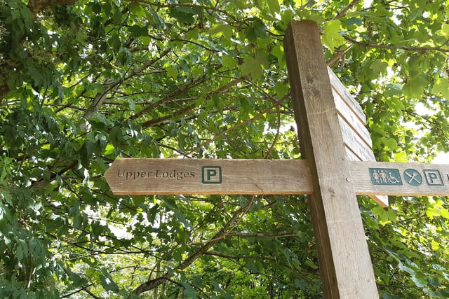
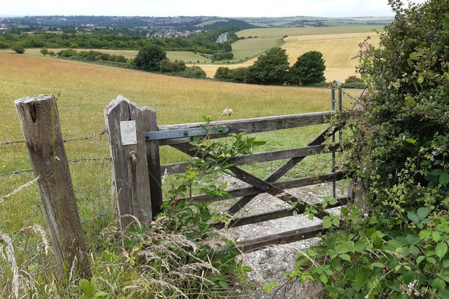
Having done Saltdean Lido to Woodingdean, then Woodingdean to Stanmer Park, this section starts at Chalk Hill Car Park at Stanmer Park, where I finished section two. The first bit is easy, a straight walk through the woods to Upper Lodges Car Park. Then you cross the road and pass through a gate on to access land. Already there are stunning views that lift your heart.
There is a gate halfway along the hedgerow but if you look to the right, you see the corner of the trees and bushes, and that is where to head for. Turn left here and follow the fence to another gate. There was a gorgeous field of poppies there the day I visited, which I loved.
You then go through another two gates into a field that is the top of a hill, so it's not so easy to see the way forward. To the right, high up on a hill, you can see the Chattri Memorial in the distance and that is where we are heading. Think of a hook shape and work you way around to the right until you see a building in the trees and a long path up to it. That is where you need to get to.
There is a gate out of the field, then you cross the road and go through another gate where the Chattri Memorial is signposted. Important note, the signpost has been twisted and seems to point to the right but the correct path is to the left of the building. This will take you uphill to a wide footpath where you turn right to visit the Chattri Memorial.
Leave by the top gate, to the west of the memorial, and follow the clear path, back past the signpost where you turned right earlier but this time carrying straight on. There are really lovely views here, too. You will go through a gate marked Sussex Border Path and end up in a small parking area. Turn right and you will find a food bar, great for a refreshment break.
You are skirting around the junction where the A27 meets the A23 now but you are quite safe. Follow Braypool Lane around to the right and look for a property called Woodsmill on the left. Turn left here to take Brownie's Bridge over the road and railway line. Follow the path a little to the left, away from the railway bridge, then turn right and follow the path around as it bends to the left to go past some houses.
We are now going to follow the path up Sweet Hill. This is where I went wrong because I was enjoying it so much! The Brighton and Hove Way curves around Waterhall but, perhaps fed up with the paths that are hard to follow, I stuck with the main one. I even found some gates making their own music in the wind! Lovely.
These gates were at a big junction and here, I turned off through a gate marked Sussex Border Path. I followed this arrowed route through another three gates and on, enjoying wide-sweeping views all the way. This brings you out to Saddlescombe Farm, a hidden gem on the South Downs Way. This hamlet nestled in the downs is run by the National Trust.
At this point on my walk, it started to rain and that helped guide my next steps. Being near Poynings, there was possibly another way down but I felt it best to stick to the clear paths, given the weather. And I met so many nice people on the South Downs Way it seemed a good omen!
Go through a gate alongside the buildings and follow the path up Newtimber Hill, with ancient woodland, chalk grassland and long-reaching views of the sea and across the Weald. You have to cross a road but no problems there, then continue to follow the South Downs Way signs until you get to a gate on the left marked Sussex Border Path.
Follow this path down the hill to a three-way signpost. The Sussex Border Path goes right here but we are carrying straight on to go over Mount Zion. You will pass a trig point and then see Foredown Tower ahead. That is going to be our end point for this section.
Cross the A27 using the Foredown Road bridge and make your way to the tower. Just down the road from here are buses back to Brighton or to Portslade. A wonderful wak through some very special places, I really enjoyed it and I highly recommend it.
1. Brighton and Hove Way walk Stanmer Park to Portslade
This walk takes you to the Chattri Memorial and offers views of the Sussex countryside at its finest Photo: Elaine Hammond
2. Brighton and Hove Way walk Stanmer Park to Portslade
This section starts at Chalk Hill Car Park at Stanmer Park Photo: Elaine Hammond
3. Brighton and Hove Way walk Stanmer Park to Portslade
The first bit is easy, a straight walk through the woods to Upper Lodges Car Park. As you near it, you just need to turn left into it, as indicated by a second signpost like this one. Photo: Elaine Hammond
4. Brighton and Hove Way walk Stanmer Park to Portslade
Then you cross the road and pass through this gate on to access land. Already there are stunning views that lift your heart. Photo: Elaine Hammond